Large-scale assessment of vegetation breakage and wave attenuation
The Delta Flume and the physical model
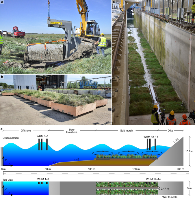
The physical model was built in the Delta Flume (a wave flume located at Deltares) by transplanting salt marsh blocks on top of a sand bed with drainage pipes. An artificial dike with a slope of 1:3.6 was constructed at the back. The Delta Flume has a length of 300 m, a width of 5 m and a depth of 9.5 m. We used 66 salt marsh blocks to construct two 71-m-long and 2.0–2.2 m-wide salt marsh profiles. In between the two rows a path was constructed 5 cm below the surface of the marsh, to drain both marsh profiles and enable access, maintenance and (manual) measurements. The height difference between the path and marsh surface was comparable with the variations in the vegetated marsh, that is, the clay heights and the vegetation height.
Blocks with a depth of approximately 0.7 m were installed at the expected erosion-prone areas: six at the seaward salt marsh edge and two at the dike toe. In between these, 25 blocks with a depth of approximately 0.4 m were installed. To connect the dike slope to the marsh, a block with a depth of 0.4 m was also installed (Fig. 1). The seaward edge of the salt marsh had an elevation difference of 0.6 m with the artificial bare tidal flat to recreate field conditions with a cliff. A brushwood dam was used as edge protection at this seaward edge of the salt marsh—similar to field locations in the Wadden Sea area43,44,45 and other regions46—to prevent lateral erosion, enabling comparison with experimental runs. The bare tidal flat was constructed using concrete to prevent bed level dynamics at the flat, which could potentially affect the incoming wave at the marsh edge. The first 40 m of the bare tidal flat had a decreasing gradient of 1:45, followed by a gradient of 1:9 over 12.5 m to create a smooth transition to the flume bottom and to save material.
Transplanting salt marsh blocks
The salt marsh blocks were collected in the field at nature reserve Peazemerlannen at the mainland Wadden Sea coast (53° 24′ 19.0908″ N, 6° 5′ 58.3476″ E) in the Netherlands. The blocks were harvested at the end of the growing season in September and October 2023. Two locations, landward and seaward, were selected with different soil compositions. The median grain size, D50, was 0.013 ± 0.010 mm (0.003 ± 0.001 mm) and the clay content was 31.4 ± 6.8% (44.5 ± 4.8%) for the seaward (landward) location (Extended Data Table 1). The particle size distribution was determined by adding a peptisator to prevent flocculation to the dried sample. The solution is left to soak for 16 h and subsequently sieved over a 63 μm sieve. The fraction larger than 63 μm was mechanically sieved over a set of sieves ranging from 63 μm to 63 mm. The particles left on each sieve were weighed and processed to determine the distribution. The smaller fraction was analysed using a sedigraph. The smaller and larger fraction together determine the full distribution.
The above-ground vegetation was similar at both selected locations to prevent vegetation gradients in the physical model. The high marsh zone was selected, as the high marsh generally contributes most to wave attenuation due to the high bed elevation15. Elymus athericus was the vegetation species dominantly present, with a mix of Atriplex spp. and Aster tripolium.
The salt marsh blocks were harvested by pushing a mould of 2 × 2 m2 (0.7 m depth) or 2.2 × 2.2 m2 (0.4 m depth) into the ground. The area around the mould was dug out using a 35-to-50 tonne excavator. A steel-bottom plate was then slid under the mould to minimiuze disturbance of the vegetation and the marsh substrate within the mould by as much as possible. Subsequently, the 3,000 to 6,000 kg marsh blocks were lifted, deployed on a closed truck to prevent wind damage, and then transported to the Delta Flume.
The harvest location was elevated above spring tide to assure safe access over land. To work safely and minimize disturbances to the ecosystem, the harvest was executed after the breeding season and before the storm season, during daylight, in the shortest period possible. Temporary steel road plates were used to distribute the weight of the excavator and trucks, which minimized damage to the marsh.
After arrival near the Delta Flume, drainage holes were drilled into the boxes around the blocks. The blocks were continuously monitored visually and saturation (by measuring weight) and salinity were periodically measured in a sub-selection of the blocks. Blocks were irrigated during dry periods after the weight dropped. From December 2023 onwards, the blocks were installed in the physical model of the Delta Flume. After installation, artificial light from growing lights was applied to the part of the physical model covered by a hall, to balance the blocked supply of sunlight. Ventilation was also applied to create a more natural air flow.
Organic matter content and root biomass of the substrate
Mean organic matter content in the salt marsh substrate in our experiment was 4.7% ± 1.7% and ranged between 2.3% and 7.6% (Extended Data Table 1). Organic matter content was determined using loss-on-ignition. The organic matter content in the substrate in our experiment is similar to many other European salt marshes, which typically range between 0 and 76.7% (mean of 8.5%)47. More specifically, studies in the Wadden Sea, Northwestern Europe show a range between 1.3% and 8.8% (mean of 4.2%)48 and in the Mediterranean between 4% and 30% (ref. 49). The organic matter content in our study is within the lower range when comparing to, for example, North American marshes, which are more organic-rich (range 0−55%)50.
Prior studies describe a rooting depth of vegetation species in salt marshes of 10 to 40 cm below the surface51. The E. athericus marsh cover has a web-like root structure (that is, dichotomous branching), with long roots compared to other species, but an average to low central root and branch density52. Vegetation roots stabilize the soil, potentially with increasing stability if the vegetation composition is more diverse53. Root mass in our experiment was measured at 5, 10 and 20 cm depth, with n (sample size) = 4. Root samples were collected after the experimental wave runs at locations where the soil was undisturbed by placing bulk density rings (6 cm diameter and 4.05 cm depth), with the midpoint at the chosen depth. The rings with material were carefully dug out, roots were gently rinsed and dried in an oven at 60 °C for 48 h, before weighing to obtain the dry root mass (g) at each depth interval. The root density was then calculated. Below-ground biomass was mainly present in the top layer in our experiment (5 cm; 78% of the total biomass; Extended Data table 2).
Our study generally implies that ecosystem services that depend on the stability of the salt marsh substrate, including wave attenuation and carbon storage54,55, are unlikely to be affected by surface erosion during extreme storms, as the marsh substrate remains stable both at low- and high-energy coasts. This conclusion is based on our flume experiment, which contains two soil types (Extended Data table 1). The organic matter content of the soil is representative for European marshes, which corresponds to the lower range of the organic-rich soils on the US East Coast and the Gulf of Mexico (Methods)50. Our experiment provides evidence for the erosion resistance of soils; however, soil parameters, and in turn erosion resistance56, vary globally, emphasizing the need for controlled erosion experiments under extreme storms with a range of established and restored marsh soils. Organic-rich soils can have a more open structure that might result in instability51, and also brackish and freshwater marshes might be more prone to erosion due to shallower root zones and potentially low inorganic sediment content21. Hence, our projection yields a conservative estimate regarding soil erodibility for salt marshes, but may overestimate the stability of organic-rich soils and brackish marshes.
The experiment
The experimental runs in the wave flume started in February 2024 to conservatively test the vegetation in its winter state. The state of the marsh vegetation installed in the Delta Flume before starting the experimental runs was equal to vegetation in the field, both measured in February 2024 (Fig. 2).
The experimental programme included three different water levels (1.5 m, 2.5 m and 4.0 m at the marsh, which correspond to 4.4 m, 5.4 m and 6.9 m at the wave paddle, respectively). The water levels were coupled with three significant wave heights (0.75 m, 1.25 m and 2.00 m; JONSWAP wave spectrum), maximizing the ratio of wave height and water depth at the marsh platform57,58. Smaller wave heights, with similar water depths (hence decreasing the wave height to water depth ratio) will result in a decreasing contribution to wave attenuation, but also less vegetation damage5. It may be expected that under these conditions the wave height at the landward side will always be smaller than under the most conservative wave height to water depth ratio we tested, as there is a limit of wave attenuation by vegetation with an increasing wave height to water depth ratio5. So, we aimed at the most conservative wave height to water depth ratio cases, enhancing vegetation damage and potentially decreasing wave attenuation by vegetation. Furthermore, two different values for wave steepness (0.04 and 0.02) were tested. These settings were combined in an experimental program with increasing water depths and significant wave heights over time, potentially resulting in increasing damage. First a short test (approximately 100 waves) was performed with water depths of 1.5 m and 2.5 m, to test the stability of the marsh, and subsequently longer tests (approximately 1,000 waves) with increasing water depths and wave heights were applied (Supplementary Table 1). This sequence was executed three times to study marsh stability and wave attenuation under potentially increasing vegetation damage: (1) light vegetation damage; (2) substantial vegetation damage; and (3) removed above-ground vegetation (Supplementary Table 1). This allowed us to explicitly quantify wave attenuation by vegetation as a result of progressive damage of the above-ground biomass, by subtracting wave attenuation by the marsh elevation in experimental runs without above-ground biomass (percentage decrease of Hm0) from wave attenuation in runs with full and damaged vegetation. Before the last repetition all vegetation was mowed level with the surface, to test wave attenuation under extreme vegetation damage potential. A significant wave height was also applied, approximating the maximum significant wave height tested by Möller et al.5, to facilitate comparison with that study (refer to Supplementary Table 1 for the full experimental program). The full range of tested wave heights allows us to generalize our findings.
Waves were forced with a wave paddle equipped with an active reflection compensation. The water level elevation in front of the wave paddle was continuously measured to observe the wave field including reflected waves. The motion of the wave paddle compensates for reflected waves to avoid reflection back into the physical model. The reflection coefficient in deep water varies between 0.2 (low waves and 4% wave steepness; experimental run SM-01 in Supplementary Table 1) and 0.35 (high waves and 2% wave steepness; experimental run SM-14 in Supplementary Table 1).
Wave flume measurements and data processing
The clay surface was measured at 32 fixed locations at the salt marsh (16 per transect) using a total station (Trimble Ri) that has a measurement accuracy of 2 mm. The concrete bare tidal flat, seaward from the salt marsh in the flume, was not subject to change. Measurements were taken daily or bi-daily and bed-level-changes (mean, s.d. and standard error) were calculated for each measurement (Extended Data Fig. 7). The s.d. (43 to 48 mm) of all 32 measurement locations exceeded the average bed level decrease over the full experiment (7 mm), highlighting that the surface decrease after 21 h of extreme wave forcing was smaller than typical elevations in the existing microtopography of the marsh (Extended Data Fig. 7).
Vegetation properties were quantified using destructive measurements (bi)daily after changing the significant wave height and daily non-destructive measurements, by (1) measuring the highest and lowest vegetation canopy height at six locations, corresponding to separate salt marsh blocks (n = 6). The canopy height was measured by carefully lowering a styrofoam plate (30 cm diameter) with a hole over a stick. Height measurements were taken after the plate was lying stably at the canopy; (2) measurements of vegetation biomass (n = 6) by collecting all above-ground biomass from a square surface of 20 × 20 cm2, taking wet weight, drying in the oven for two weeks at 65 °C and taking dry weight; (3) measuring stem characteristics (E. athericus) by randomly selecting 20 standing stems from the marsh (n = 20). The length of each stem and outer diameter 5 cm above the base were measured using a caliper; (4) measuring total biomass removal (that is, flotsam) due to wave exposure by collecting all vegetation material at the dike and in the water with a fishing net made from chicken wire. Total wet weight was measured, and subsequently a wet subsample was taken and weighed. The wet subsample was dried for two weeks at 65 °C in an oven, whereafter the dry weight was taken; (5) measuring stem characteristics from already broken stems in the flotsam by randomly collecting 20 stems (E. athericus) from the flotsam after experimental runs. Subsequently, length and diameter were measured analogously to the standing stems, and flexural strength was measured. The destructive measurements for biomass (vegetation measurement 2) and stem length (vegetation measurement 3) affected a marsh area less than 1% of the total salt marsh in the physical model.
Vegetation stems (E. athericus) were collected in the field at the seaward and landward location (n = 75) where the salt marsh blocks were harvested. Stems were collected in February 2024 at the start of the experiment to allow comparison of the development of vegetation next to and in the flume with that in the field.
Vegetation stem length and dry biomass measurements were post-processed by calculating the mean, median, quartiles, inter-quartile range and standard error (Figs. 2 and 3). An exponential decay function was then fitted (Fig. 3), and then used to quantify vegetation damage over exposure time. Wave attenuation was related to stem length per wave height class, that is, significant wave heights of 0.75 m (r2 = 0.89), 1.25 m (r2 = 0.57) and 2.00 (r2 = 0.33; Fig. 3). Significant differences between above-ground biomass in the field and flume at the start of the experiment were tested using a Mann–Whitney U test. Significant differences in increasingly damaged vegetation height and biomass were tested using a t-test for normal and Mann–Whitney U test for non-normally distributed samples with a Benjamini–Hochberg FDR P-value correction. Significant differences over the total experiment were tested using a Welch t-test with Benjamini–Hochberg false-discovery rate (FDR) P-value correction. The few statistical differences might have been caused by the high variability of stem height and above-ground biomass at the marsh, and for the latter also the limited number of replicates to damage the marsh as little as possible.
Wave characteristics were measured using fixed resistance-type wave gauges present in the Delta Flume at the left wall of the flume (looking from the wave paddle to the end of the flume) with a measurement accuracy smaller than 1 cm (ref. 59). No variations in the width direction were discernible during experimental runs, because the setup was symmetrical in the width direction. We assume no variations in width, as is the case in general for flumes (as width, 5 m « length, 300 m)60. For every experiment, Hm0 is determined in front of and at the landward end of the marsh by using the three wave gauges in front of the marsh (locations X = 40.5, 43.5 and 49.5 m; Fig. 1) and at the end of the marsh (locations X = 151.4, 159.1 and 160.8 m; Fig. 1). Zelt and Skjelbreia’s method, using three wave height meters, was used to separate incoming and reflected waves61. Hereafter, the difference in wave height in front of the marsh and at the landward end of the marsh was calculated. Subsequently, wave attenuation was quantified. The explicit contribution of vegetation was quantified by calculating the difference in wave attenuation for the experiments with (Supplementary Table 1; experiment SM-1–29) and without (Supplementary Table 1; experiment SM-30–37) vegetation. Wave attenuation by vegetation was calculated as the relative share of the incoming wave to enable comparison of different experimental runs and global scenarios.
Calculating the global contribution of breaking vegetation
Development of the statistical model
The global contribution of breaking vegetation to wave attenuation is explored by a parameterization where wave attenuation is a response variable of the predictor variables exposure duration and incoming wave height. The assessed E. athericus (also Elytrigia atherica) is widespread in Northwestern European salt marshes, appearing in for example, Denmark, Germany, the Netherlands, United Kingdom, France and Portugal (Extended Data Fig. 1). Stem height decrease of E. athericus through exposure duration in this large scale experiment (Fig. 3) is used as a conservative estimator of wave attenuation by above-ground vegetation under the most severe conditions (water depth to wave height ratio of 0.5).
To explore the contribution of salt marsh vegetation to wave attenuation globally, a GLM is applied with a Tweedie distribution and a log link function enabling the use of zeros and positive continuous data and proportional effects (for example, exponential decrease of wave attenuation with increasing exposure duration). The GLM is a strong predictor of the variability of wave attenuation by vegetation (pseudo-R2 = 0.97). Wave attenuation by vegetation decreased with increasing incoming wave height (β = −1.3258, SE = 0.185, z = −7.16, P < 0.001) and longer exposure duration (β = −0.0494, SE = 0.011, z = −4.42, P < 0.001). The GLM including incoming wave height and exposure duration is a globally significant predictor compared with the null intercept-only model (χ² = 59.26, df = 2, P < 0.001).
Stem height in salt marshes as proxy for wave attenuation
Key for the functionality of the marsh is the presence of salt-tolerant vegetation (halophytes), such as herbs, grasses and shrubs, which typically depend on salinity and inundation gradients4. The stem height of the vegetation is an important parameter for wave attenuation. Stem height is used as a proxy for wave attenuation as penetration of the stem in the water column is considered a strong predictor of wave attenuation, especially under extreme wave heights and water levels13. As a result, damage to vegetation by a decreasing stem height will have a direct impact on wave attenuation. The stem height and biomass of E. athericus are comparable with global marsh vegetation species that carry stems. At the end of our experiment, both the values of the damaged stem height and biomass were lower than global values for (other) salt marsh vegetation species (Extended Data Fig. 1) throughout the year.
Increasing wave attenuation with stem height can be expected both at low- and high-energy coasts, and is also found as a result of the flume experiment (Fig. 3). Yet for high-energy conditions, the higher risk of damage may cancel this benefit. Comparing Elymus with Spartina spp., locally a species growing at a lower elevation and regionally a dominant species in, for example, North America62,63, wave-induced damage to Spartina spp. is lower due to a higher flexibility26. Hence, attenuation can be expected to be higher as more stems and biomass persists (Fig. 3). Attenuation can also be expected to increase towards a lower salinity environment, since due to decreasing environmental stress, species diversity increases32,33,64.
70% of the salt marshes globally present are found in the temperate climate zone and therefore experience a winter season31. In general, the vegetation state at the end of the winter can be considered to yield a conservative estimate for vegetation stem height, as vegetation outside the winter season, for example, in the growing season, is more resistant26. Nevertheless, vegetation will be damaged during extreme storms, also when being more resistant early in the winter season, and might reduce wave attenuation during consecutive storms. Furthermore, E. athericus in our experiment can be considered to yield a conservative estimate of wave attenuation, because its breaking force is relatively weak compared to other salt marsh vegetation species35. Less vegetation damage leads to longer stems persisting and hence a higher wave attenuation capacity. In addition to this, we tested a single salt marsh zone, whereas salt marshes in general contain multiple zones that enhance the wave attenuation capacity65. Finally, only a small (70 m) part of the marsh was considered for wave attenuation. Our experiment enables future site-specific assessments of wave attenuation through vegetation height. These quantifications require extensive vegetation characterization (for example, spatiotemporal variable height). Effective methods for mapping vegetation heights are available through remote sensing, for example: high-resolution satellite imagery, LiDAR and Photogrammetry66,67,68. However, these techniques still require extensive field validation, especially if vegetation composition is variable.
Global datasets to determine salt marsh transects and wave exposure
Global wave attenuation along salt marsh foreshores is estimated by using global data layers as input for the statistical model. The approach to derive coastal profile data is based on a previous global study focused on wave-attenuation on vegetated foreshores29. We incorporated several updates: (1) elevation data from DeltaDTM was used30 instead of MERIT69 and vegetation extent data was updated31; (2) we filtered foreshores that are preceded by waterbodies with a minimal length of 1 km using a global water mask70 to assure that foreshore data are derived at the right location; (3) salt marsh areas sheltered behind higher landscape features, such as dunes, were excluded by flagging vegetation presence as false if the mean elevation in the vegetated zone is lower than the mean elevation of the preceding non-vegetated foreshore data points; and (4) false positives of vegetation presence in areas with steep transitions (for example, steep coastal slopes or cliffs) were corrected by applying an Interquartile Range filter on elevation within vegetated areas with a multiplier of 1.5. In general, this filtering resulted in an equal reduction across continents.
Following our experiment, nearshore waves at the seaward salt marsh edge are estimated to be 50% of the water depth, slightly lower than 55% estimated for very flat nearshore areas29,57,58. Using the global datasets, exposure duration during a single storm with a recurrence time (RPS) of 100 to 1,000 years was calculated for 1 km spaced transects where salt marsh vegetation is present.
Next, we combined the derived elevation profiles, salt marsh extents and significant wave heights with global storm tide hydrographs28, based on Euclidean distance, to calculate inundation depths and consequential exposure duration. Globally observed peak water levels (exceeding 1 m water depth) at the globally derived salt marsh locations remain for the larger part (around 90%) within the water level range applied in the wave flume. Globally observed exposure duration with water levels exceeding the threshold of 1.0 m (with Hm0 of 0.5 m) did not exceed 1,000 min (16.67 h), which is within the duration of the flume experiment (21 h). Subsequently, this information is used to calculate vegetation damage, specifically the expected decrease in stem height. As stem height damage in the Delta Flume experiment started already during the most tranquil hydrodynamic conditions (h = 1.50 m; Hm0 = 0.75 m), the initiation of stem height damage in the global model was set following previous controlled flume experiments28. In those previous experiments, which started at water depths of 1 m and wave heights of 0.1 m, the first significant stem damage was observed after water depths of 1 m and wave heights of 0.5 m on average27. Using the local storm surge hydrographs, exposure duration for vegetation damage is calculated over the time window during which wave heights at the marsh exceed 0.5 m from the start of the storm until the point in time when the highest waves occur, that is, at the peak of the storm surge hydrograph. The maximum incoming wave height at the marsh edge is calculated at the peak of the storm, with the most severe estimate for the wave height being 50% of the water depth29,57,58. Finally, wave attenuation at the peak of the storm is calculated using the GLM, as potentially the highest depth-limited waves occur at this point.